
Issue #249: Redistricting Wars Part 1: The Long Blight of Gerrymandering in America
How does the current map look?

Several weeks back, Republicans in Texas began the process of redrawing their Congressional districts. This mid-decade redistricting was not due to a court order, or due to a change in laws. No, the effort is happening because Republicans, at the behest of Donald Trump, are openly stating their goal is to remap Texas to increase the number of Republican-leaning districts. Why? Its simple - to help ensure Republicans hold Congress in the 2026 midterms.
This brazen move is the latest escalation of redistricting and gerrymandering fights that have gone on for decades. Gerrymandering, best defined as drawing apportionment lines to achieve a desired outcome, has existed in one form or another for the entire nation’s history. However, the rise of sophisticated technology and the rise of a cottage industry around the practice has taken things to a new level. Now, as Americans find themselves with a President who shows no regard for political norms or democracy, the practice of gerrymandering has been further weaponized the way any authoritarian aims to stay in power - to rig the elections.
Before delving into the current fight over Texas’ map and potential other state fights, I wanted to use this article to delve into the current state of gerrymandering in the country. Trump allies have made many claims about the extend of pro-Democratic Party gerrymandering in the current House map, and I want to address that. This article will address the current state of the map and the (short) history of gerrymandering. A follow-up article will cover the current fights ongoing as we speak and how Democrats should respond.
Gerrymandering in America
It never stops amazing me that America handles the drawing of Congressional and legislative districts the way it does. Unlike many other advanced Democracies, even many newer democracies, America still allows lawmakers themselves to draw electoral districts.
In most of the country, state legislatures redraw their own lines and those for Congress as well. You can see full details on each state from Ballotpedia, but the map below shows each state’s method for its Congressional redistricting.
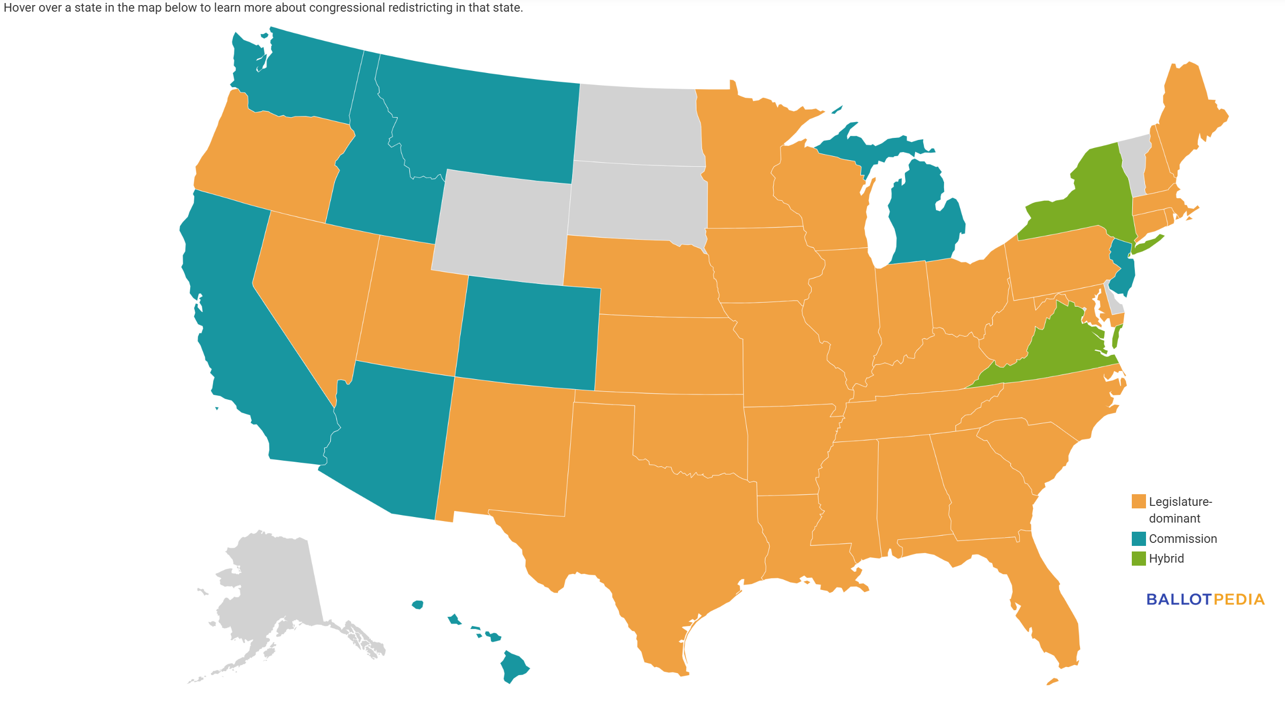
A vast majority of states still have the legislature draw new lines. An increasing number have adopted commissions, which vary from being as a-political as possible to being a bipartisan commission made up of political actors. Every commission system has pluses and minuses, but are infinitely better than leaving it in the full hands of elected officials.
In other nations, like the United Kingdom or Canada, redistricting post-census is handled by boundary commissions. These boards vary by nation, and I’ll spare full details here, but the point is they are largely a-political and aim to shift districts to meet population and other requirements, while not focused on aiding a political party. You can read about the UK boundary commissions here and what their process looks like, as an example. The process is far less political than in America, and the UK actually passed additional laws in recent years to further remove politics from the process.
No boundary commission is perfect, and I have heard complaints about places like Canada and the UK, especially over issues around unique communities and population balance. However, all of those issues pale in comparison to the system we use in America.
Gerrymandering from The Start
The fact that our Constitution was drafted with no mandates for independent boundary commissions is one of the biggest errors in the document. Even by the time of the US Constitution’s drafting, the issues of gerrymandering and malapportionment (where districts don’t have equal population) was well known in England and the colonies. We even saw efforts to gerrymander lines for colonial parliaments decades before the 1776 Revolution.
On this point, I cannot recommend enough this book by Nick Seabrook: One Person, One Vote - a Surprising History of Gerrymandering in America. As Seabrook’s book goes over, gerrymandering predates the first time the practice got major coverage; or had a name associated with it. Efforts to draw lines with specific political goals date back to the Carolina colonies. In fact, in the first gerrymander for Congress may have been in the very 1st Congress. In 1789, James Madison was elected to Congress from the Virginia 5th district. That district, some speculated, was drawn by Governor Patrick Henry, who sought to fit Madison in an anti-federalist leaning district. This effort, dubbed the “Henrymander” - has been debated by historians and contemporaries.
The moment that the issue of “gerrymandering” really hit public attention was the debate over the infamous Massachusetts State Senate map, which was signed into law by Governor Elbridge Gerry. The plan in question aimed to cement Democratic-Republican control in the chamber over the Federalists. A state Senate district that snaked around the outskirts of Essex County was parodied in the Boston Gazette with this now-famous political cartoon.
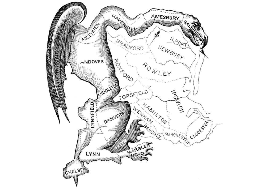
While Governor Jerry was not involved in the mapping process, and privately expressed distain for the map, he did sign his party’s plan into law. Hence the district, which looked similar to a salamander, was dubbed a “Gerry-Mander.” This forever tied Gerry’s name to the practice. Despite having a long career in Revolutionary America, including serving as Vice President, Elbridge Gerry is best known today for the issue of “gerrymandering.”
Still, for all the outcry over the issue at the time, no efforts succeeded in changing the practice of gerrymandering took place. Decades went on with different states having assorted gerrymanders. Maps were often far more compact in that era, with the sophisticated technology not available for complicated maps. However, issues with political bias and poor population balance were common. It was not until the 1960s, namely with the case of Wesberry v. Sanders, that the Supreme Court ruled that Congressional districts had to be nearly equal in population as possible.
While the courts would assert their authority when it comes to malapportionment and issues around racial gerrymandering, they would not make decisions based on partisan gerrymandering claims. A list of major court cases on redistricting can be seen here.
Modern Era Battles
Heading into the 21st century, without court restraints, gerrymandering only increased as a tactic to secure political control. Both parties would wield gerrymandering whenever they could. You can see this in my Florida redistricting history series. There you can read about the Democratic gerrymanders of the 1980s and 1990s give way to the Republican gerrymanders of the 2000s. No party was clean of this effort.
New Tech and New Trends
Gerrymandering was was made easier as voters further sorted themselves into areas based on politics and ticket-splitting decreased. It was easier than ever to predict how a district would perform if drawn in a specific way. This allowed parties to employ experienced data consultants to craft maps that would make them immune from electoral consequences.
Republicans made a special push, known as REDMAP, to control redistricting in as many states as possible following the 2010 census. Thanks to a strong midterm win, Republicans held full control of several swing states as they began the remapping process. They succeeded in passing excessive legislative and congressional gerrymanders across the country, helping them lock in a Congressional majority. For example, the 2012 elections saw Democrats win by 1% of the nationwide House vote, but fell 33 seats short of winning Congress. While Democrats had managed to gerrymander some states, Republicans had more control and more ability to shape the map thanks to their 2010 midterm win. A good summary of this story can be read here.
The mid 2010s saw efforts by Democrats to push lawsuits over maps in many states; namely aimed at maps with some anti-gerrymandering provisions in their state constitutions. Successful remaps in places like Pennsylvania, Virginia, Florida, and North Carolina created more balanced maps than the GOP gerrymanders. In the 2018 midterms, Democrats managed to win control of the House after winning the nationwide popular vote by 9%.
In the 2020 House elections, Democrats won the nationwide vote by 3% and held 9 more seats than Republicans. As Crystal Ball pointed out, if it had not been for the court-ordered remaps between 2012 and 2020, Democrats likely would have fallen short of a majority despite winning the popular vote. This showed that the court-ordered remaps made the House more responsive to national mood.
Reform Efforts in Recent Years
Through the post-2010 era, several efforts at reform took place. One of the biggest pushes was within individual states to establish redistricting limits or independent commissions. Battles over Supreme Courts also became a major focus; aiming to get courts that would strike down bad maps. The coalition for reform was largely Democrats and good government groups. Republican pushes for reform have been contained to states like Maryland and Illinois where they suffer under gerrymanders. However, the broad national Republican Party position has been ANTI reform.
Democrats and good government groups also pushed for the federal courts to make a decision on curbing partisan gerrymandering. While the courts already asserted their jurisdiction on matters of racial gerrymandering, they had been warry of getting involved in partisan map debates. Democratic Attorney Generals backed the courts asserting themselves on striking down partisan gerrymandering, while Republicans opposed the effort. In 2019, the Supreme Court ruled 5-4 in Rucho v. Common Cause that while partisan gerrymandering was anti-Democratic, the court would not regulate the issue. The ruling fell on ideological lines, with the four liberal justices in the dissent.
After the 2020 elections, Democrats in Congress pushed for a nationwide redistricting reform bill. The For the People Act, filed as HR.1, was introduced in the first Biden term. The proposal, along with several voting right reform proposals would mandate independent redistricting in every state. These efforts failed thanks to Republican filibustering in the US Senate; with all Republicans voting to block the bill from going for a final vote. In the house, meanwhile, every Republican voted against reform. Republican opposition was responsible for the 2021 - 2022 redistricting process going on without any national anti-gerrymandering standards.
So with no national standards in place, what happened after the 2020 census?
Current Gerrymandering
Efforts to reform redistricting post-2020 census proved a failure. So what was anyone to do at that point? Well, I think this report from the Guardian perfectly sums up what happened in the 2021-2022 redistricting process.
Without the threat of a national, court-enforced standard, states had no reason to behave themselves. In 2021, Democrats – now fully awakened to the problem – claimed seats in Illinois (14 of 17) and Maryland (seven of eight) and took extra seats in Oregon, Nevada and New Mexico. Republicans, already enjoying an edge, claimed four in Florida then worked the margins in Texas, Tennessee, Indiana, Oklahoma, Georgia and Utah.
With no national standards from Congress or the courts in place, gerrymandering happened where it could. In states with firm party control and no commissions, the map-makers went wild. It was often only the presence of a commission or split party control that resulted in maps without extreme bias.
How to judge a map’s bias can be tricky, but the Princeton Gerrymandering Project has an extensive analysis of the current Congressional being used. Their “Redistricting Report Card” can be seen below. (Note: this pre-dates New York’s remap in 2023/2024 and the 2024 court-ordered Louisiana re-map).
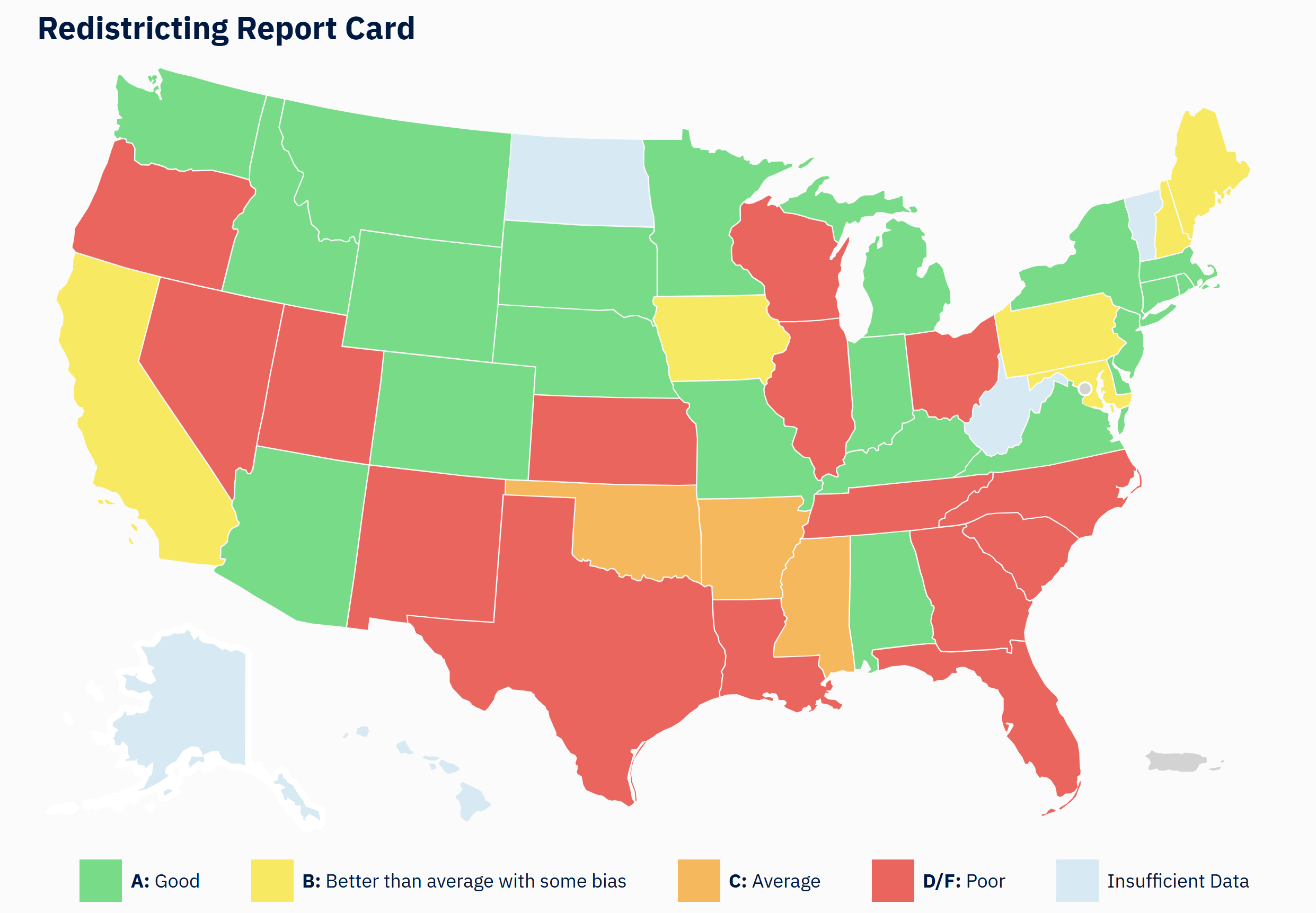
The analysis in the link includes all details on their methodology. The report looks at county splits, considerations of racial and language minority groups, and efforts to rig the map for partisan benefit. As the map shows, may states, red and blue, fall under the D or F category.
Now I cannot go through each state and each issue, but I have some key points to lay out below. This section will focus on clear partisan gerrymandering.
Where the Maps are Rigged
There are no shortages of gerrymanders in the current Congressional map. I’ll highlight some key states below, but its hardly a full list. You can also see what several redistricting experts considered their most extreme gerrymanders of the 2022 mapping process.
BTW, an important note for this section. As I look at maps passed, I will be referencing 2020 Election data, not 2024. Why? Because I am looking at the intent of lawmakers drawing the lines at the time. Someone drawing lines in 2022 didn’t know how 2024 would go.
Of course, Texas is the biggest news story since it is planning to redraw what is already a pretty extreme gerrymander. In 2021/2022, Republicans redrew Texas to create a map with as little chance for Democratic upsets as possible. After the 2016 and 2020 elections saw Democrats make gains in the suburbs around Dallas and Houston, Republicans restructured the map to pack Democrats into several DEEP DEEP DEEP BLUE seats in the core cities. Only the border communities remain modestly competitive.
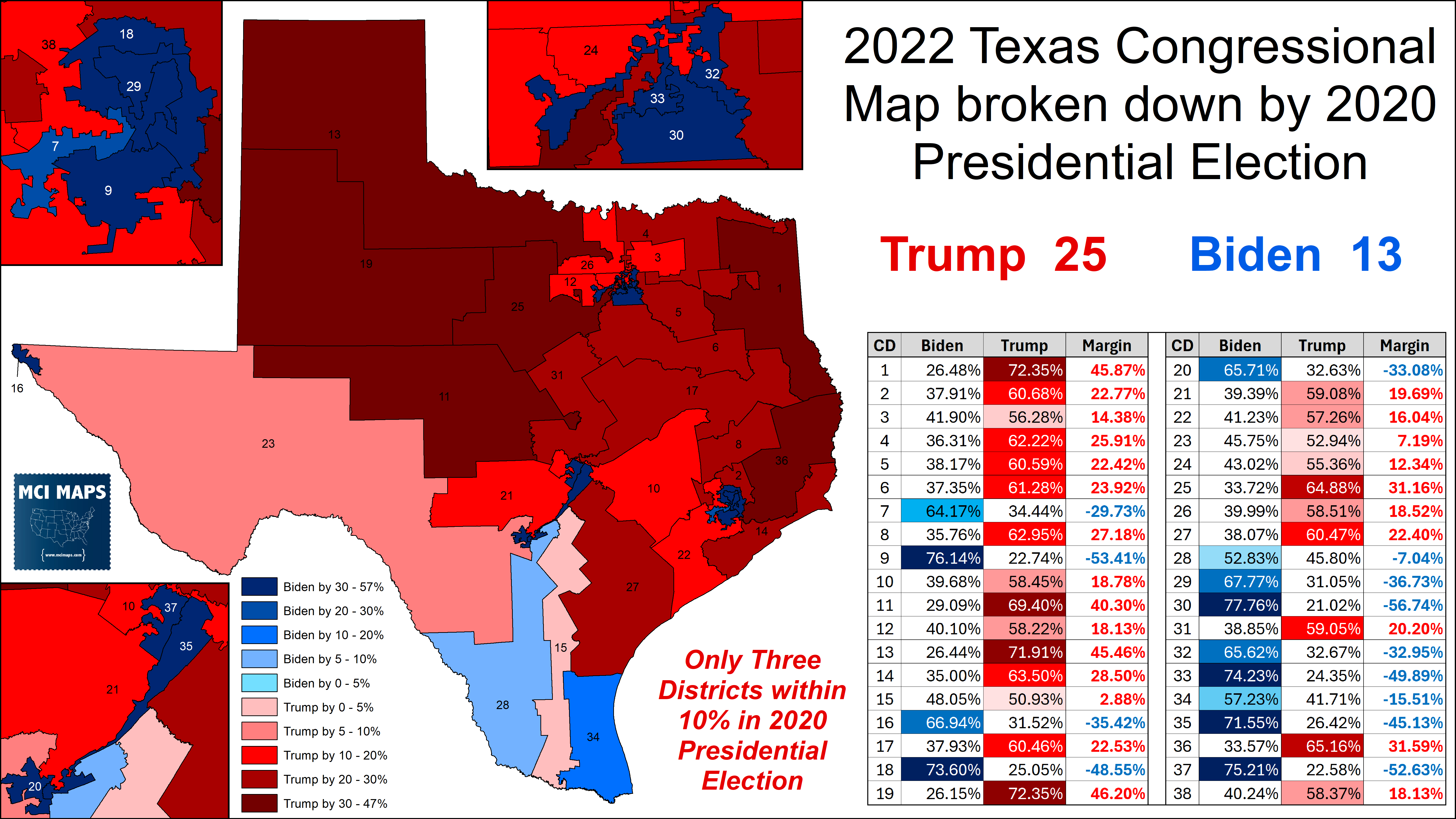
The map overall has just three districts that were within 10% in the 2020 Presidential election. Any Democratic gains outside of the border region are blocked. Republicans now aim to further expand the number of Trump districts in the state, but we will talk about that in a future article.
Illinois has often been sited as one of the most extreme Democratic gerrymanders. Republicans have consistently brought up the state has a counter protests about the Texas remap. Indeed the map is an extreme gerrymander. There, the Democratic trifecta managed to squeeze Republicans into 3 deep-red districts; leaving 14 Democratic-leaning seats in place.
Of special note is the 13th and 17th districts; which travel across rural communities to connect Democratic voters. The closest Democrat-held seat backed Biden by 8% in 2020. Any Republican gains in Illinois would be the ultimate of upsets.
Florida, meanwhile, was home to a massive redistricting battle; something many of you know I covered extensively. My Issue 200 covered the full battle in detail here, while my last issue covered the latest Florida court rulings on the elimination of the Black-performing 5th district. Despite Florida’s constitution banning partisan gerrymandering, DeSantis managed to force lawmakers to pass an extreme Republican gerrymander that packed Democrats into 8 of 28 seats.
The map, which has held up under a right-wing Florida Supreme Court, is very inelastic, with Democratic wins in 2018 yielding the same number of seats as Biden got. Likewise, Trump’s big 2024 win saw him gain no additional districts despite doing 10% better than 2020. More details on the map can be seen here. Original drafts by the Republican legislature would have seen Florida with four additional Biden seats. DeSantis bragged in his 2024 Presidential campaign that the map was drawn to aid Republicans in the 2022 midterms.
Big states like Illinois, Texas, or Florida have the most attention from the press. However, we cannot forget the small level gerrymanders that happened elsewhere.
In Tennessee, for example, Republicans opted to crack the city of Nashville, eliminating the Democratic lean of the 5th Congressional district. For many years, a Nashville-dominated seat was one of just two Democratic seats in the state. With 2022’s remap, Republicans openly stated they would crack Nashville to create another Republican district. The plan that passed compared to the 2012 plan can be seen below.
This resulted in a guaranteed Republican pickup in the 2022 midterm, which came to pass.
Meanwhile, Utah Republicans carried out a similar practice. In the 2012 map, Utah’s legislature made sure to crack Salt Lake City and its metro community between all four of the state’s congressional districts. Such a move prevented a Democratic-leaning district to form in the region. Good government groups and Democrats backed a 2018 ballot measure to move Utah to independent redistricting commissions. However, the legislature altered the bill to make the commission “non-binding.” Once that was done, Republicans passed their own bill that continued cracking Salt Lake County.
The split of Salt Lake County, which holds over 1 million residents, ensures all four districts in Utah remain Republican.
There is no shortage of partisan map decisions across the country. A few others of special note are….
In Oregon, Democrats moved to shore-up the 4th district, which had backed Biden by just 4% in 2020. Their new 4th was Biden +12%. Republicans have been packed as much as they can be in the 2nd, which backed Trump by 24 points. The only close seat is the 5th, which had backed Biden by 8% in 2020.
In Oklahoma, Republicans worked to shore-up their map after a Democrat flipped the 5th district in the 2018 midterm (but lost it back to the GOP in 2020). That district, which backed Trump by 5% in 2020, was anchored in Oklahoma City. The new map cracked the city and leaves no district backed Trump by less than 16% in the 2020 election.
In New Mexico, Democrats redrew the map to turn the long-Republican 2nd into a blue-leaning seat. The original district backed Trump by 9% in 2020 and Democrats redrew it to be Biden by 6%.
In Kansas, Republicans tried to remap the 3rd district, held by Democrat Sharice Davids, to cost her re-election. The old 3rd was anchored in Kansas city suburbs and was Biden +11%. The remap added rural areas to take it down to Biden +5%. However, Davids has held on. Republicans effort to remap without causing any other district to become swingish led to awkward lines around Topeka.
In Nevada, Democrats spread out the last Vegas metro area to ensure 3 of the 4 districts remained firmly Democratic and backing Biden from 7% to 9%.
In Georgia, Republicans packed Democrats further into Atlanta and cracked the growing blue suburbs around the city. This succeeded in eliminating the swing districts that had emerged in the suburban ring around the city; packing two Democratic incumbents into one seat.
There is no shortage of map issues across the country. I have not touched on all issues here. It does, however, highlight this is a pervasive problem.
Redistricting Post-2022
If the 2021/2022 mapping process wasn’t filled with enough gerrymandering, even more took place after the midterms.
The most extreme remap took place in North Carolina. Initially the Republicans, who control a veto-proof majority in the legislature, tried to pass a gerrymandered map. However, the state courts rejected the proposal for violating the state constitution, leading to a much more balanced map. However, after Republicans flipped control of the State Supreme Court in 2022, that new right-wing court ruled the legislature could redraw as they saw fit. The result was the map we see below.
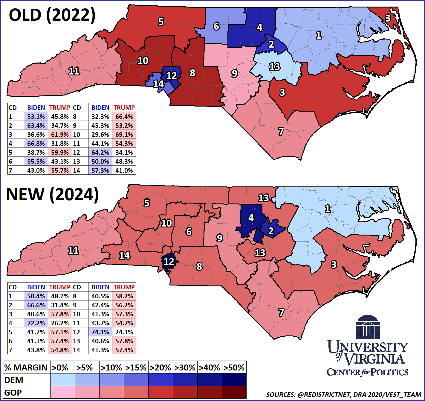
You can read the full details on this remap here. The proposal led to Republicans flipping four seats in the 2024 House elections.
As North Carolina redid their map, New York Democrats were able to pass modest changes to their map. New York’s system, which partly relies on a commission to draw maps, will be discussed more in my next article. Democrats had initially tried to draw an extreme gerrymander in 2021/2022, but the courts rebuffed them. The court in 2023 did allow them to redraw the map, but the changes could not be all-encompassing. A more detailed breakdown can be seen here.
How the districts voted in the 2020 Election between the original and updated maps can be seen below.
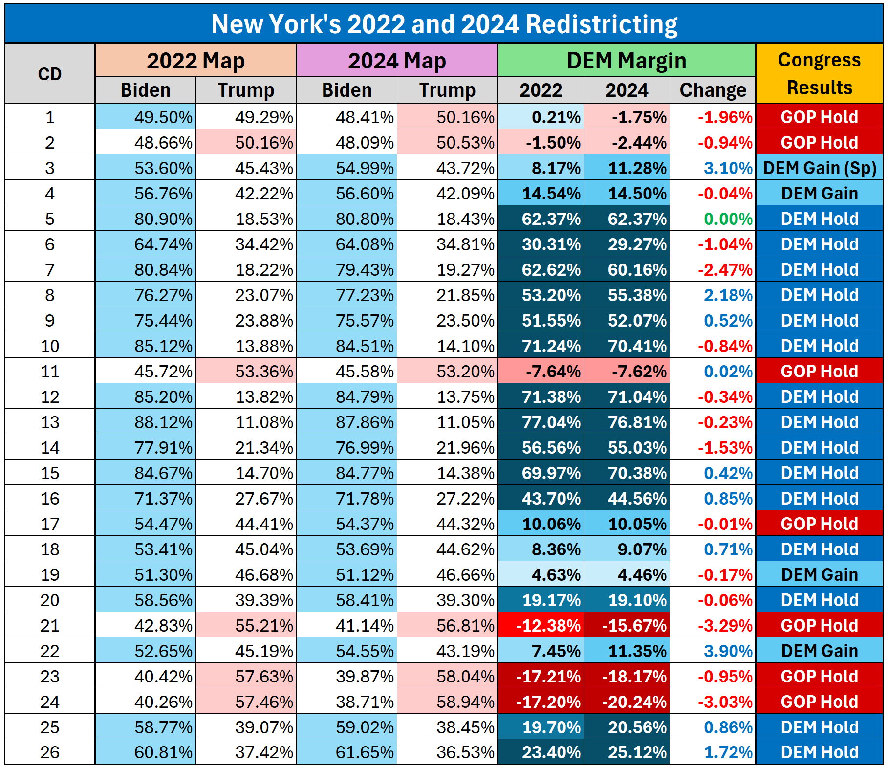
Republicans have sited that Democrats gained four seats in the 2024 House elections as proof of an extreme 2024 gerrymander. However, two of the gains came in districts that saw little partisan change. Another district, the 3rd, was initially won in a special held under the old lines. That said, there were clear efforts here to shore-up Biden seats and make them more likely to elect Democratic Congresspeople. It still, however, is not as DEM-friendly as it could be. I will discuss that more in the next article, as Democrats are threatening to try for a more extreme gerrymander in response to Texas.
Finally, both Alabama and Lousiana saw remaps as well, both due to court orders. Federal courts ordered remaps that saw new Black-performing districts drawn for the states, as both had a long history of packing Black voters into just one districts instead of the two that could be made. Both those redraws saw each state elect new Black Democratic Congresspeople. There made the state delegations closer to matching the statewide margin.
Geography is not Bias
As debates over redistricting have continued, many have sited different states with little or no representation for either party, despite said party getting a decent amount of statewide votes. Sometimes this is due to gerrymandering, but other times it is a party being hurt by geography. In some instances, a party support can be spread out and hence not easy to consolidate into a single-member district. In other instances a party is too clustered and packed into districts that are otherwise very compact.
Many states have these issues….
In Wisconsin, Democrats would at best be poised to be favored in 3 of 8 districts, verses just the two right now. Much of their vote base is concentrated in Milwaukee and Madison, making a 4/4 map unlikely even within an un-biased commission drawing the map.
In Connecticut, Republicans are spread out in the state, making a Republican-favored seat hard to draw, the one district has been a battleground at times.
In Arizona, a commission drawn map came out with 3 Democratic seats, 4 Republican seats, and 2 GOP-leaning seats. This is thanks to bad geography for Democrats leading to them being clustered in districts along the southern border of the state.
In no state has this issue come up more than Massachusetts. This is namely thanks to the 9-0 Democratic delegation for the state becoming a major GOP talking point in the last few weeks. However, as many have pointed out, that map was signed into law by a Republican Governor. The reality is, Republicans are spread out in the state, similar to their issues in Connecticut. In 2021/2022, if the legislature wanted to draw a GOP-leaning seat, the best they would have been able to do is draw this Biden +1 seat.
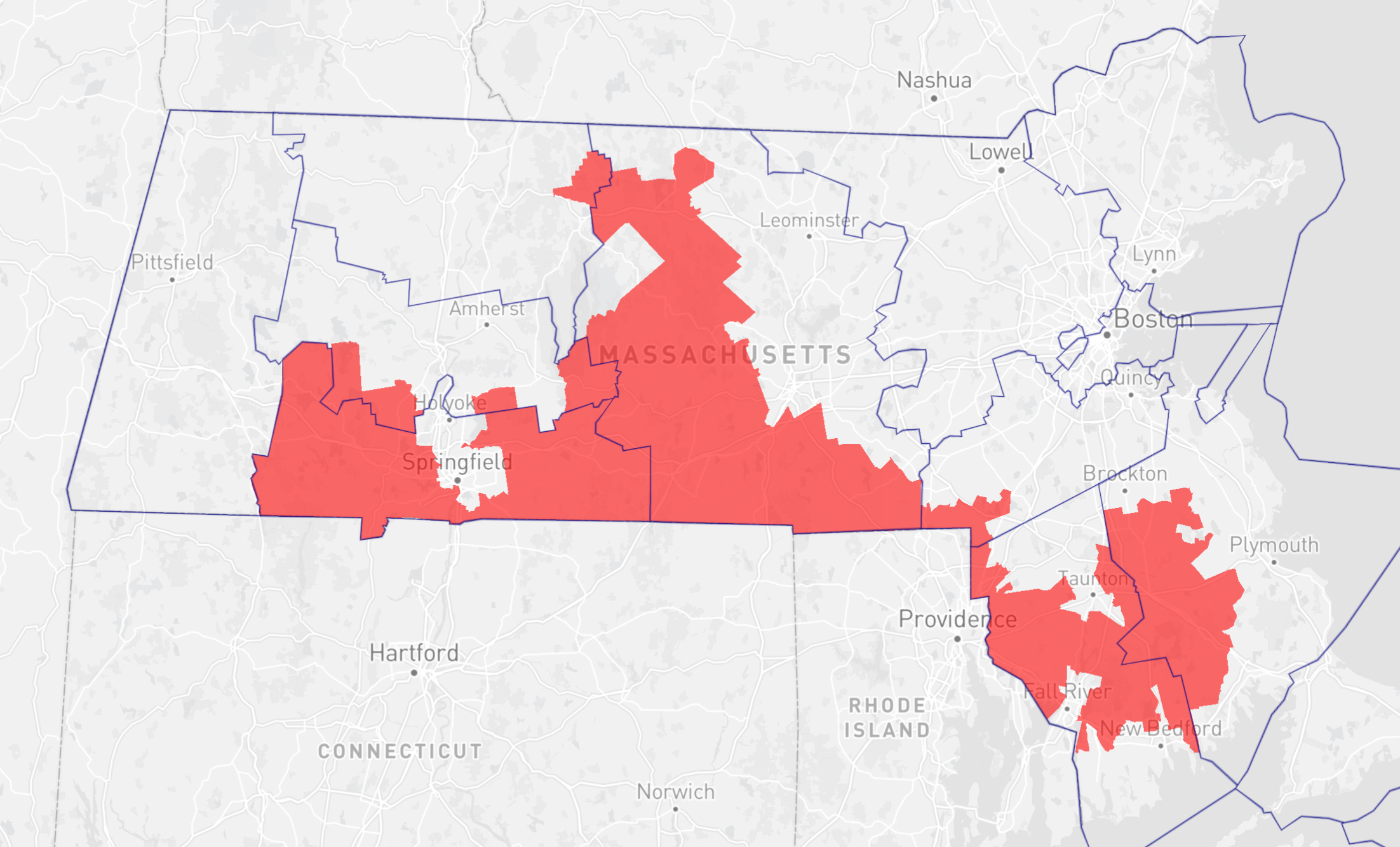
Republicans have limited success in Massachusetts outside of Governor races. Back in 2019, a study on this redistricting issue in the state summed up the struggles for Republicans when it came to getting a district they could win.
Several of these elections have a remarkable property in their vote patterns: Republican votes clear 30%, but are distributed so uniformly that they are locked out of the possibility of representation. Though there are more ways of building a valid districting plan than there are particles in the galaxy, every single one of them would produce a 9–0 Democratic delegation.
Trump made gains in 2024 in the state’s working-class voter pool, which would actually make the seat I drew a Trump district by a few points. However, that district would still likely lean heavily Democratic down-ballot. Also the question then becomes, if a district like this should be drawn for the GOP, then shouldn’t Democrats in states like Arkansas or elsewhere?
The easiest solution to geography leading to map bias would be proportional representation of multi-member districts. In a world of single-member districts, geography can sometimes be very hard to overcome. That is not the same as gerrymandering.
The Current House Map Balance
Sooooo, with all that said, what is the current status of the nationwide congressional map?
As the redistricting debate over the last few weeks has enfolded, partisans on both sides have selectively highlighted different state gerrymanders to argue the entire House is biased for or against their party. While both parties are guilty of gerrymandering in different areas, several different studies all point to Republicans benefitting from the collective US House map.
We can look at the study done by the Brennan Center for Justice. The study came out in September of 2024 and found that thanks to gerrymandering efforts, there were a NET 16 more Trump districts (using 2020 President) than otherwise would have been if all states used non-gerrymandered maps.
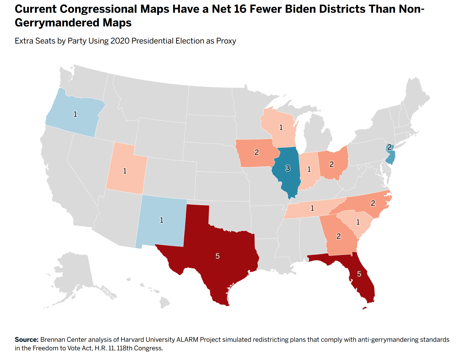
The study goes into full details on its methodology and discusses each state in question. Some states, like New Jersey or Indiana, I didn’t even have time to get into. However, the study has many more details on the maps across the nation. I’ve seen no study pointing to a Democratic bias in the nationwide map.
After the latest round of redistricting battles are done, we will need to see where things stand. On that topic……
Looking Ahead
As I finish this article on the night of Wednesday the 13th, the word is California will release its proposed redistricting map, which is being used to counter Texas, the next morning. Its entirely likely a draft from California will be out by the time you all are reading this.
In my next article, I will look at the fight in Texas and how other states are responding. Democrats are threatening maps in California and New York, while Republicans are also looking at remaps for Missouri and Indiana. Alot is happening, and its frankly all a travesty.
But I’ll leave that to Issue #250