Issue #44: A Good Friday analysis of a Bad Redistricting Map
DeSantis final product is out
Well here we are. During Holy Week, talking about redistricting still. Most of you will be reading this on Good Friday. Well its time to talk about a bad map.
As expected, Ron DeSantis has finally released his preferred Congressional map. This comes a couple weeks after Ron followed through on his commitment to veto the legislative-passed plan. DeSantis directed most of his ire in the veto message on North Florida. He claimed, incorrectly, that the legislature was violating the 14th amendment with the 5th Congressional district. DeSantis has long railed against the east-west configuration of the 5th district, claiming it only links two cities (Tallahassee and Jacksonville together).
I have delved deep into the justifications for the 5th district before. Read here if you are interested in its history. HOWEVER, it must be reiterated that this is not the map Ron vetoed. Ron vetoed this plan.
After Ron made his veto threats clear, lawmakers tried to accommodate his concerns, drawing a Duval-only 5th district, which aimed preserve minority communities. Analysis showed the seat would very likely perform as an African-American district.
Despite being compact and balancing minority voter concerns, Ron claimed the district was a racial gerrymander. This is an objectively false claim that has no current legal basis. I delved deep into this situation in my article on Ron DeSantis’ long history of disrespecting the black community of Florida. DeSantis is no doubt counting on a more conservative court to side with him. How the modern, GOP-heavy courts will rule is up in the air. What is clear is the Duval-only 5th would clearly be in line with current case law.
Ron’s motivation here is to offer red meat to conservative activists. There was a great deal of anger at early legislative drafts as they became available. The Senate’s draft map, which was much more balanced, was especially hated in right-wing circles.
How this would shake out was made clear over a week ago. Ron DeSantis has spent much of the last few weeks making it clear to lawmakers that they were not to defy him on this. Threats of primaries and line-item vetoes of budget items were made clear. There was little doubt that when Ron released his proposal, it would be rubber-stamped by lawmakers.
On Wednesday, we got out map from Ron DeSantis - the THIRD plan he’s released.
The map, as previous versions of his proposals indicated, was 20 Trump districts to Biden 8 districts. This is the conservative dream map. It aims to compact Democrats into as few districts as possible while cracking minority communities elsewhere.
The map reduces the number of performing-black districts from 4 to just 2! The 20th and 24th districts will be African-American seats. The historically-black 5th is destroyed, while the 10th loses a large chunk of black voters.
Similar to the legislature, the map has four Hispanic districts. The 26th, 27th, and 28th are all super-majority Hispanic seats (which have existed in some form since the early 2000s). The 9th district is a new Hispanic-majority district, reflecting the growth of Puerto Rican voters in the Orlando region.
Go here for an interactive version of the map with demographic data.
Lets delve into this; how the map compares to what the legislature had passed.
Notable Difference
Ron’s final plan is a combination of legislative-passed districts and his own lines. Several districts in his plan are exactly the same as what the legislature passed a few weeks back. Those districts are highlighted below.
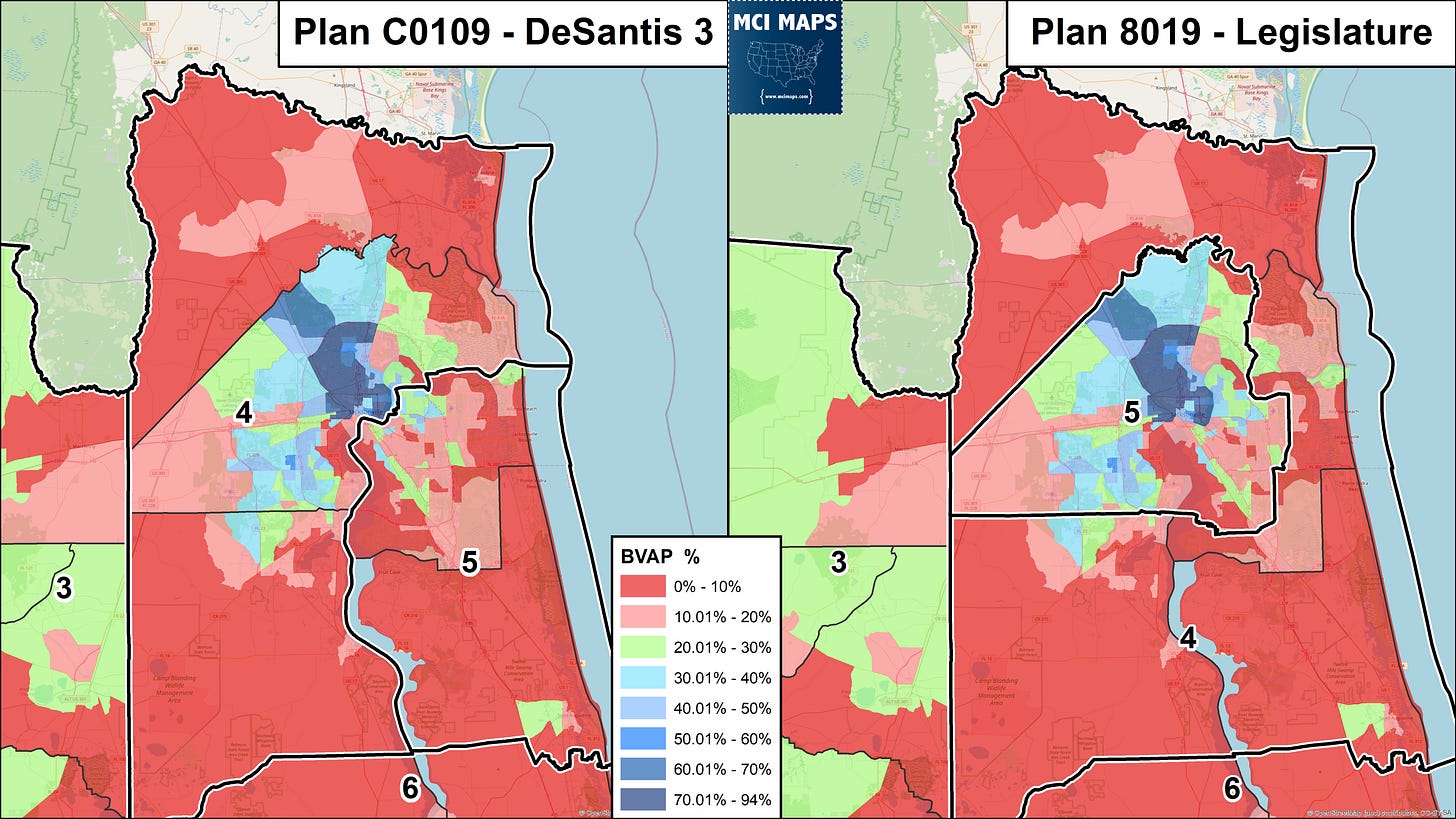
Jacksonville is the most impactful difference. As the image to the right shows, the legislature had aimed to create a 5th district that incorporated the minority communities of Duval County. DeSantis’ plan, meanwhile, splits those diverse communities by going down the St Johns River.
Ron’s plan splits up the growing diverse communities of the east and lumps them in with SE Duval and St Johns. Meanwhile, the historic African-American community of Duval is paired with rural Nassau and blood-red Clay County. These lines aim to crack minority voters and pair them with white Republicans.
In the Orlando region, the 10th district is reshaped. The State Senate viewed the 10th, which is a racially diverse district that when drawn was deep blue and had a 50% black Democratic primary, as a protected black-access seat. The final legislative product aimed to keep the black population of the region together, creating a seat where black and white voters were at near-parity in the democratic primary. DeSantis’ map cuts the black community in two.
DeSantis’ lines create a 10th district that is 5 points whiter. Why is this done? Because DeSantis wants to grab as many white and Hispanic democrats as possible, keeping them out of the 7th (which is made much redder in this plan).
In Tampa Bay, DeSantis’ map is clearly a partisan gerrymander. The legislative plan continued the current layout by having the 13th district making up south and central Pinellas County. DeSantis’ proposal grabs part of Pinellas, splitting St Petersburg in two, and crosses the water to grab western Tampa. This makes the 14th deep blue, while both the 13th and 15 are modestly Republican. St Petersburg and Tampa have their black communities divided by lines.
The Tampa Bay region continues to grow more diverse. This diversity growth was reflected by many different maps, with different partisan breakdowns. DeSantis’ plan is by far the most conservative, packing Democrats into one seat. In the legislative plan, the 13th was narrowly Democratic while the 14th was solidly blue.
Polk County loses out in this plan as well. The county has long been a “donor county” in redistricting - giving off pieces to other districts. Most drafts gave Polk its own Congressional seat; a reflection of its large growth. DeSantis’ plan, however, divides Polk into four seats. Polk will still control the 18th (light blue) - with about 70% of the population coming from there.
However, for all of Ron’s talk about the old 5th being “too long” - he’s created a district that takes a good 200 miles to drive across.


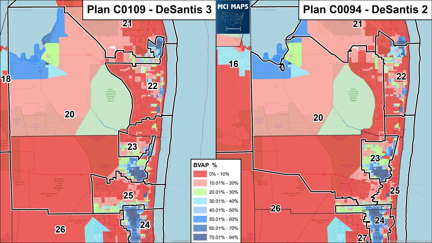
Finally, in South Florida, DeSantis agreed to adopt the legislature’s layout. For comparison, I included what his second map (released weeks back) offered for South Florida. The region has had two black-performing districts (often black majority in the census) since the 1990s. There would be no real way to gerrymander those out, due to the whole region (outside Hispanic Dade) being so Democratic. DeSantis’ 2nd plan initially had the 24th and 23rd as the black-performing seats. However, the 23rd only included Broward’s black population. The new plan has districts 20 and 24 as African-American districts.
Lawmakers always intended to keep pairing the black populations of Palm Beach and Broward together, like they have been since the 1990s. This means going into EMPTY Everglades land. Many will question this layout, but it is something I support - as it is desired by the South Florida black community. The district just held a special election to replace Congressman Alcee Hastings. DeSantis clearly acquiesced to the legislature there - which was easy for him since it doesn’t change the partisan breakdown. I must emphasize this next point.
Is Ron going to tell me he thinks the 5th district is too long, but he’s ok with the 20th? And he has issues with the Duval-only 5th the legislature proposed? It is clear, more than ever, this is all about partisanship. Ron doesn’t care about compactness.
Ron only cares about compactness when he can use it as a partisan tool.
Looking Ahead
This map will be passed. The legislature will meet next week and there is little doubt the lawmakers will rubber stamp it. It is a racist and vile map. It will be subject to lawsuits. I do think this is likely to be our map for the midterm though - as a trial will take time and its already mid April.
Ok I’m done, going back to my reading. If anyone knows how I can get a copy of the book below to Ron Desantis, let me know. He should read it over Easter.


This article is extremely important and I want to share broadly, but I'm a bit confused on this point: would you please clarify for me? "Ron claimed the district was a racial gerrymander. This is an objectively false claim that has no current legal basis." As a 'layperson,' it appears to me that statement conflicts with this one, "What is clear is the Duval-only 5th would clearly be in line with current case law" Is the Duval-only 5h actually inline with case law? Maybe a different question, but I would have thought case law, both fed and state, would protect the existing dst 5 boundary.