Issue #21: More State Senate Redistricting Draft Maps
Five new drafts came out around Thanksgiving - all small changes
Over the Thanksgiving holiday, the Florida Senate redistricting committee released nine new plans. Five were for the State Senate, four for Congress.
As discussed in this previous substack post, the first sets of drafts from the committee all had largely decent lines; with no clear gerrymandering present. The plans were not perfect; specifically issues with the Tampa Bay and Broward County on the State Senate side.
So we have new drafts of the maps released earlier this month. What does this mean? Are these gerrymanders being hidden via releasing on a Holiday?
Nope.


The plans posted over Thanksgiving largely just offer technical changes. Some so small as to just move a couple blocks (often to keep a city/town from being split) - or offer a new idea on how the borders should look.
All plans keep a near-identical partisan breakdown for Congress and Senate; same as seen in the original drafts.
I’ll dedicate a different post to the Congressional map. Lets do a quick State Senate look.
The State Senate Plans
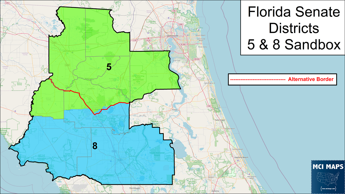
The State Senate drafts, five in total, are in agreement on many districts. The maps divide the state into some "sandboxes” where differing borders for specific districts are offered. The map below colors-in districts with unanimous agreement. The white-out areas have border debates.
All alternative plans offer a similar partisan makeup. For example, here is a partisan layout for Plan 8026.
Compare 8026 with the other four plans, and the differences are very minor.
The closest thing to a GOP improvement is the already super-close SD37 gets 0.1% more GOP. This is happens due to the movement of a couple precincts.
The Sandboxes
So lets take a quick look at these sandboxes. Each image shows the debated borders for specific districts. All follow a similar layout, the blue/green districts show one of the layouts offered, while the red border line shows an alternative border offered in one or multiple plans.
Some of these changes are small, some are large. None effect the partisan nature of the districts in a major way. They often exist as staffers debate trade-offs like keeping cities whole vs population deviations.
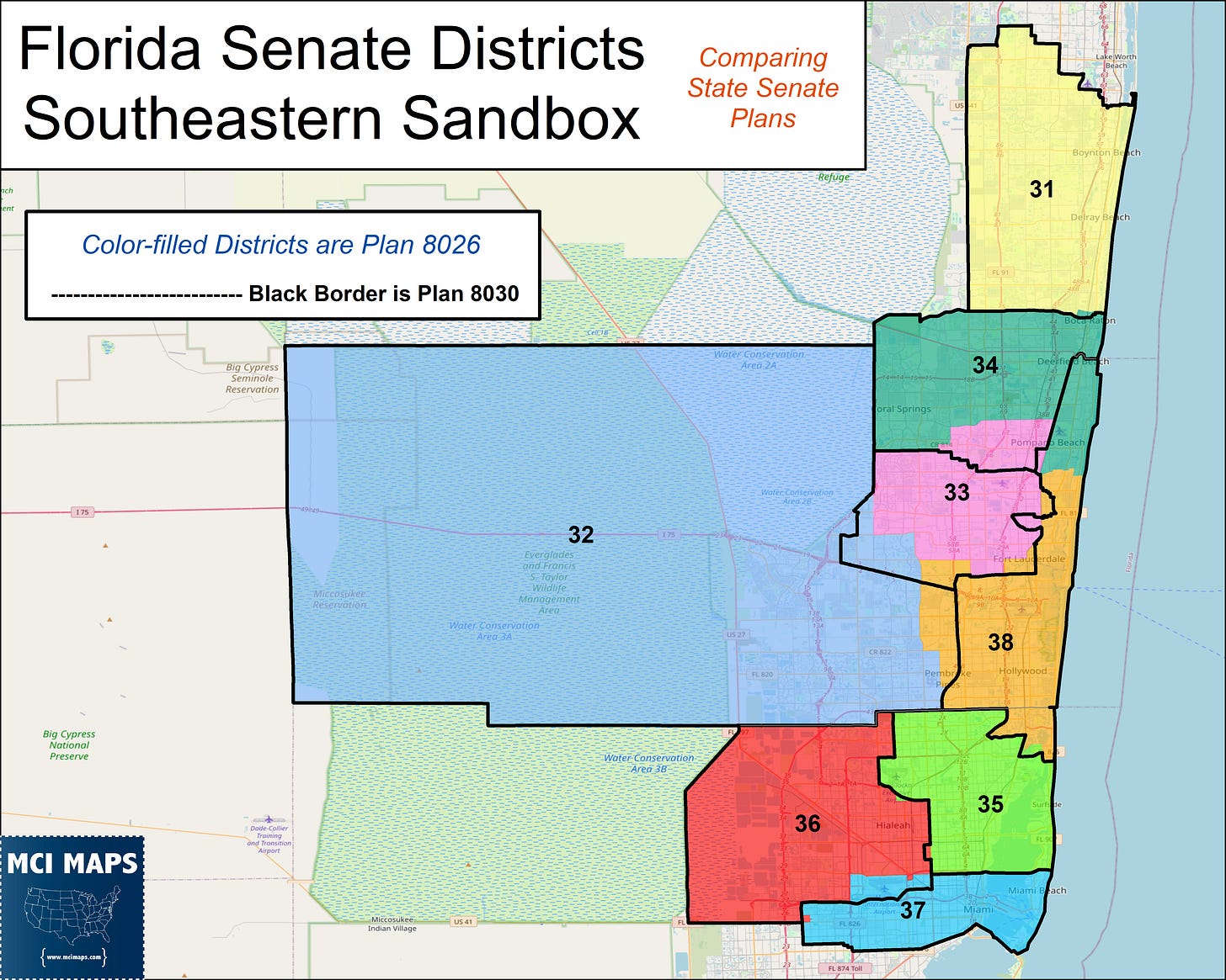
Southeast Florida has by far the most debate in it - specifically the Broward region. The five plans offer borders with some modest or dramatic changes.
See the different plans below. All follow a similar format. Color-filled districts are plan 8026, black borders are the plan indicated in the legend.
Districts 31, 36, 35, and 37 all have very minor changes across the plans, while the rest sometimes have major changes. These again don’t effect the racial or partisan layout too-much. Though all these plans fail to address the racial issues I laid out in my Broward article.
BTW, plan 8034 is in fact the same as plan 8032; except one difference - lines that no longer split the small town of Lauderdale-by-the-Sea. This is an example of small technical changes happening.
For a full breakdown of how district lines change over plans, I offer this table below. Most districts have a Version 1 or Version 2, but as you see with South Florida; more versions pop up.
(For example, SD1 is the same under all plans by 8028 - so on).
District 38 holds the distinction of being different under all plans! Hooray for it.
Keep an eye on my twitter for any redistricting news as it breaks.


